
|
Introduction
New estimates of poverty show that the proportion of people living in poverty in South Africa has not changed significantly between 1996 and 2001. However, those households living in poverty have sunk deeper into poverty and the gap between rich and poor has widened. The Human Sciences Research Council (HSRC) in collaboration with Mr Andrew Whiteford, a South African economist, has generated these estimates.
Approximately 57% of individuals in South Africa were living below the poverty income line in 2001, unchanged from 1996. Limpopo and the Eastern Cape had the highest proportion of poor with 77% and 72% of their populations living below the poverty income line, respectively. The Western Cape had the lowest proportion in poverty (32%), followed by Gauteng (42%). See Table 1.
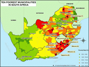
The HSRC has estimated poverty rates for each municipality. The majority of municipalities with the lowest poverty rates are found in the Western Cape. These include Stellenbosch (23%) and Saldanha Bay (25%). The major city with the lowest poverty rate is Cape Town (30%). Pretoria and Johannesburg have somewhat higher rates of 35% and 38%, respectively, while Durban has a rate of 44%. The poorest municipality is Ntabankulu in the Eastern Cape, where 85% of its residents live below the poverty line. The figure below shows that seven of the 10 poorest municipalities are located in the Eastern Cape while two are located in Limpopo and one in the Free State.
While the poverty rate measures the proportion of a region’s population living below the poverty line it does not give any indication of how far below the poverty line poor households are. For this the HSRC has used a measure called the poverty gap that measures the required annual income transfer to all poor households to bring them out of poverty. The HSRC study has shown that the poverty gap has grown from R56-billion in 1996 to R81-billion in 2001 indicating that poor households have sunk deeper into poverty over this period.
Table 1. Poverty indicators by province
| Province |
No. of poor persons (million) |
% of population in poverty |
Poverty gap (R billion) |
Share of poverty gap |
| Eastern Cape |
4.6 |
72% |
14.8 |
18.2% |
| Free State |
1.8 |
68% |
5.9 |
7.2% |
| Gauteng |
3.7 |
42% |
12.1 |
14.9% |
| KwaZulu-Natal |
5.7 |
61% |
18.3 |
22.5% |
| Limpopo |
4.1 |
77% |
11.5 |
14.1% |
| Mpumalanga |
1.8 |
57% |
7.1 |
8.7% |
| North West |
1.9 |
52% |
6.1 |
7.5% |
| Northern Cape |
0.5 |
61% |
1.5 |
1.8% |
| Western Cape |
1.4 |
32% |
4.1 |
5.0% |
| South Africa |
25.7 |
57% |
81.3 |
100.0% |
Figure 2. Poverty rate (%) in South African municipalities
With its large, poor population KwaZulu-Natal has the biggest poverty gap (R18 billion). The Eastern Cape and Gauteng follow KwaZulu-Natal. The Gauteng’s poverty gap has grown faster between 1996 and 2001 than all other provinces. This is probably a result of its population growth rapidly exceeding economic growth. Among municipalities, Durban has the largest poverty gap, followed by Johannesburg and East Rand.
The poverty gap has grown faster than the economy indicating that poor households have not shared in the benefits of economic growth. In 1996 the total poverty gap was equivalent to 6.7% of gross domestic product (GDP); by 2001 it had risen to 8.3%.
The fact that poorer households have not shared in the proceeds of economic growth is reflected in the rise in inequality between rich and poor. To measure inequality the HSRC have used the Gini coefficient, which can vary from 0 in the case of a highly even distribution of income, to 1 in the case of a highly unequal distribution. South Africa’s Gini coefficient rose from 0.69 in 1996 to 0.77 in 2001. While historically South Africa has had one of the most unequal distributions of income in the world this rise is likely to place it at the top of the world rankings.
In the past inequality in South Africa was largely defined along race lines. It has become increasingly defined by inequality within population groups as the gap between rich and poor within each group has increased substantially The Gini coefficient for the African population has risen from 0.62 in 1991 to 0.72 in 2001. This level of inequality is comparable with the most unequal societies in the world. The white population has a Gini coefficient of 0.60 that is extremely high for a group whose education and occupational profile matches that of societies in highly industrialised countries.
Table 2. Gini coefficient by population group
| |
1991 |
1996 |
2001 |
| African |
0.62 |
0.66 |
0.72 |
| White |
0.46 |
0.50 |
0.60 |
| Coloured |
0.52 |
0.56 |
0.64 |
| Asian |
0.49 |
0.52 |
0.60 |
| Total |
0.68 |
0.69 |
0.77 |
Methodology
Aggregate Poverty Gap The poverty gap measures the difference between each poor household’s income and the poverty line. Thus, it measures the depth of poverty of each poor household. The aggregate poverty gap is calculated by summing the poverty gaps of each poor household. Therefore, it is equivalent to the total amount by which the incomes of poor households need to be raised each year to bring all households up to the poverty line and, hence, out of poverty.
The poverty line varies according to household size, the larger the household the larger the income required to keep its members out of poverty. The poverty lines used were based on the Bureau of Market Research’s Minimum Living Level.
Table 3. Poverty income by household size (R per month)
|
Household Size
|
2001
|
|
1
|
587
|
|
2
|
773
|
|
3
|
1028
|
|
4
|
1290
|
|
5
|
1541
|
|
6
|
1806
|
|
7
|
2054
|
|
8+
|
2503
|
In order to calculate the aggregate poverty gap a cross tabulation of household income by household size, municipality and race was drawn from the 2001 census. This data, viewed together with the poverty income data shown in Table 1, enables the number of households living in poverty and the poverty gap of each poor household to be determined. The poverty gap of each poor household was summed to arrive at the aggregate poverty gap for each municipality.
Gini Coefficient
The Gini coefficient is a summary statistic of income inequality that varies from 0 (in the case of perfect equality where all households earn equal income) to 1 (in the case where one household earns all the income and other households earn nothing).
Figure 2. Lorenz curve

The Gini coefficient is calculated from the Lorenz curve that plots the cumulative percentages of total income received against the cumulative number of recipients, starting with the poorest household. Figure 2 shows a hypothetical Lorenz curve. The Gini measures the area between the Lorenz curve and a hypothetical line of absolute equality, expressed as a percentage of the maximum area under the line. In geometric terms the Gini coefficient is measured as:
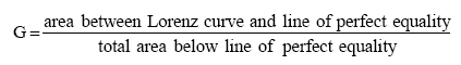
In a situation of perfect equality the Lorenz curve would overlap the line of perfect equality and the Gini coefficient would equal zero. In the theoretical situation of one household earning all the income, the Lorenz curve would coincide with the axes and the Gini coefficient would equal one.
The Gini coefficient was estimated for each municipality by calculating the area between the Lorenz curve and the line of perfect equality. As census income data is presented in income categories an assumption was made that each household in an income category earns the category midpoint. Under this assumption the Lorenz curve is a series of connected chords.
Available geoinformation
The GIS Centre provides a geoinformation database in various GIS file formats with the poverty variables listed in the table below and linked to the municipality boundaries of South Africa. Also included in the database is a full set of variables from the 2001 census, including age, employment, gender, population group, education, dwelling type and population group of household head.
Various other variables and spatial data sets that are housed in the HSRC’s GIS Centre can be provided. For example, the Gross Geographic Product (GGP), service needs and provision and poverty indicators from 1996 and 2001 can also be provided.
|
VARIABLES
|
DESCRIPTION
|
|
GC_AFRICAN
|
Gini coefficient: African population
|
|
GC_COLOUR
|
Gini coefficient: Coloured population
|
|
GC_ASIAN
|
Gini coefficient: Asian population
|
|
GC_WHITE
|
Gini coefficient: White population
|
|
GC_TOTAL
|
Total Gini coefficient
|
|
NPOOR_AF
|
Total number of poor: African
|
|
NPOOR_CO
|
Total number of poor: Coloured
|
|
NPOOR_AS
|
Total number of poor: Asian
|
|
NPOOR_WH
|
Total number of poor: White
|
|
NPOOR_TT
|
Total number of poor: All races
|
|
PRATE_AF
|
Poverty rate (%): Africans
|
|
PRATE_CO
|
Poverty rate (%): Coloured
|
|
PRATE_AS
|
Poverty rate (%): Asian
|
|
PRATE_WH
|
Poverty rate (%): White
|
|
PRATE_TT
|
Poverty rate (%): Total
|
|
PG_AFRICAN
|
Poverty Gap: African
|
|
PG_COLOUR
|
Poverty Gap: Coloured
|
|
PG_ASIAN
|
Poverty Gap: Asian
|
|
PG_WHITE
|
Poverty Gap: White
|
|
PG_TOTAL
|
Poverty Gap: Total
|
Cost
To enable the GIS Centre to update its statistics on an annual basis, it needs to generate external funds for this purpose. Therefore, it has been decided to make the data in a database or GIS format available at a cost, which is listed below. Maps on the poverty indicators and selected variables can be accessed for a small consultancy fee in a PowerPoint slide presentation. Further spatial and statistical analysis of the data can be requested from the HSRC’s at a relevant consultancy fee.
Poverty indicators GIS – R5 000 per site (per annum)
NOTES
-
Poverty estimates are calculated using a poverty line that varies according to household size. A household of 4 persons has a poverty income of R1 290 per month.
-
All monetary values are measured in constant 2001 prices.
-
1996 poverty gap and Gini coefficients from Whiteford, A.C and van Seventer, D.E. 1999. Pretoria: WEFA Southern Africa. 1991 Gini coefficients from Whiteford, A.C and McGrath, M.D. 1994. Distribution of income in South Africa. Pretoria: Human Sciences Research Council.
-
Andrew Whiteford is acknowledged as the economist that developed the poverty indicator figures on behalf of the HSRC.
Contact:
Mr Johann Fenske, GIS Consultant, GIS Centre
Human Sciences Research Council (HSRC)
Private Bag X41, Pretoria, 0001
Tel: +27 12 302 2600, Fax: +27 12 302 2525
|
|


 Related documents
 - 275Kb ~ 2 min (5 pages)